India’s border with Pakistan is surely among the most controversial ones, and not just in Asia, but it is among the most talked-about borders in the entire world because there have been so many conflicts regarding this between the two nations. Today, though, we’re here specifically to look at the Indian states that border Pakistan. So let’s just get to that then.
The Backstory Of the Pakistan Border With Indian States
The border between India and Pakistan is quite literally one of the most talked-about borders in the entire world, mainly for the dispute that is going on every now and then. But talking about the technical and factual side of it, see, it covers a distance of around 3,323 km from the chilly mountains of Ladakh in the north to the Arabian Sea in the south. And yes, this border was created in 1947 when India got divided and Pakistan was separated as a new country.
Over the years, this border has seen it all, you know, negotiations for peace, wars, and periods of tension. It is far more than a mere line on the map. It is pretty much the center point of history, politics, feelings, and, of course, the current problems between these two nations.
How the Border Is Divided
The India-Pakistan border is not one single line. Nah! In actuality, it is divided into different sections:
- International Boundary (IB): Runs through Punjab, Rajasthan, and Gujarat
- Line of Control (LoC): Separates Indian and Pakistani-controlled parts of Jammu and Kashmir
- Working Boundary: Between Jammu (India) and Pakistan’s Punjab region
- Sir Creek: A disputed marshy area between Gujarat and Sindh
- Actual Ground Position Line (AGPL): Runs through the Siachen Glacier, the world’s highest battlefield
Sure enough, since this is a super sensitive topic, each section has its own strategic and political importance.
Indian States and Union Territories Along the Border
The border touches five regions in India:
- Jammu & Kashmir: Around 1,222 km
- Ladakh: Around 857 km
- Punjab: Around 425 km
- Rajasthan: Around 1,170 km
- Gujarat: Around 506 km
Indian States That Border Pakistan
1. Jammu & Kashmir and Ladakh: The Mountain Zone
First, and of course, in Jammu & Kashmir and Ladakh, the border is situated amidst towering mountains and glaciers. These areas comprise the LoC as well as the Siachen Glacier, where soldiers work in frigid conditions of below -50°C. The region is of great strategic importance because it borders both Pakistan and China.
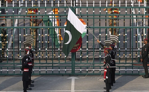
2. Punjab
Surely, people mostly know about the border Punjab shares with Pakistan because of the Wagah-Attari Border. Each day, soldiers from the two sides execute the Beating Retreat ceremony, which is watched by heaps of spectators. It is in Punjab that the Attari Integrated Check Post is located, which is one of the main points of official trade between the two countries.
3. Rajasthan
And then, no doubt, Rajasthan shares the longest border with Pakistan than any other state, this border stretches along the Thar Desert. Surely, the unfriendly terrain poses challenges to both surveillance and movement. This place witnessed intense fighting during the war of 1971, particularly at Longewala. Ever since, sure enough, fencing has been put up by India along the vast majority of this portion, and border roads are still being constructed to facilitate patrolling and to curb unauthorized entries.
4. Gujarat
You must be hearing a lot about it recently, like, Gujarat is a border state with Pakistan’s Sindh province. The border dispute over Sir Creek is still unresolved mainly due to disagreements on the boundary line and fishing rights. The Rann of Kutch, a salt desert that gets flooded during the monsoon, is also a part of this area. Zero Point, or the southernmost point, is the location of the last Indian village on the Pakistan border.