Without a single doubt, right now, as of 2026, Nepal is the only neighboring country that has the most peaceful border with India. To be specific here, it is a stretch of 1,751 km of open border, and the transition from India to Nepal won’t even feel like you’re crossing or going from one nation to the other. Why? Well, the culture is pretty much the same as the states of India that share a border with Nepal. That’s a big reason right there. And just in case you’re planning your tour or something like that, or maybe you were just curious about it all, and that’s why you want to know more about the Nepal Border with Indian States, then just keep on reading because that’s what today’s post is all about.
Little Bit Of The Background of the Border
Yes, there is an open border between India and Nepal, and if we talk about the history of it, well, then it can easily be traced back to the Anglo-Nepalese War (1814-1816), a conflict that happened more than two centuries ago. While, for a long time, there was no distinction between the two regions, Nepal was forced to cede some territories in the Terai and Kumaon-Garhwal areas as a result of the Treaty of Sugauli after the war. But, under the British Raj, no doubt, they faced quite a lot of issues with this border when it was handed back to them in 1816.
Thankfully, though, both countries had decided to keep the existing boundary line after India became independent in 1947. And just, just a few years down the line, a 1950 Peace and Friendship Treaty not only maintained free movement but also allowed the border to become gradually a symbol of shared history, trade, and cultural ties.
Indian States Sharing the Border with Nepal
Now let’s talk about the main part, which you must have come here for, right? So, how many states of India share a border with Nepal? In total, there are 5 states! Nepal has its border with India to the south. In fact, Nepal shares its southern border with five Indian states, each of which plays a crucial role in cross-border interaction.
1. Uttarakhand
First of all, there is Uttarakhand that shares a border of about 275 km with Nepal. Here, in this state, important border points like Banbasa and Jhulaghat are situated here, mainly along the Sharda River in the hilly region.
2. Uttar Pradesh
Then, there is the 2nd largest border of any Indian state with Nepal, and here comes Uttar Pradesh that shares around 551 km of border. Talking about specifics here, see, key border points like Sonauli-Belahiya and Rupaidiha-Nepalganj make this an extremely busy section for both trade and travel.
3. Bihar
And then, let’s talk about the largest stretch of border of any Indian state with Nepal, and that’s where we must talk about Bihar. It stretches nearly 726 km! The Raxaul-Birgunj, Jogbani-Biratnagar, and Bhitthamore-Jaleshwar are the main border towns on the fertile Terai plains.
4. West Bengal
West Bengal shares a border of almost 100 km in the Darjeeling district, and Panitanki-Kakarbhitta is the main border crossing point near the Siliguri Corridor.
5. Sikkim
Sikkim shares its shortest border with Nepal of about 99 km, passing through the high Himalayan mountain terrain and linking to eastern Nepal.
Border Movement and Checkpoints
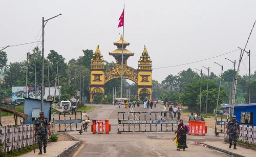
Even though the border between India and Nepal is peaceful, it is still very active. Thousands of people cross it daily for work, trade, education, and family visits. The major border crossings are through Integrated Check Posts (ICPs), and these include Raxaul-Birgunj, Sonauli-Belahiya, Jogbani-iratnagar, Rupaidiha-Nepalganj, and Banbasa–Dodhara Chandani.
Besides, smaller local border crossings called Chhoti Bhansar points help in village-level trade and short-distance movement. Rail connectivity has also been enhanced as the Jaynagar-Bardibas railway line is already operational, and routes like Raxaul-Kathmandu are being developed as we speak.