No doubt, Bangladesh is among the newest neighboring countries to India, and it was just in 1971 when Bangladesh came to be. But right now, after so much of a peaceful time with them, India is facing a big illegal immigration problem, and that’s why a lot of people are talking about the strengthening of the border with Bangladesh. And among that, to get more information on this topic, now a lot of people are searching for which Indian states border Bangladesh as of 2026. So, if you were looking for that very information, we’re here to deliver it to you in the simplest way possible. Here:
How This Border Came to Be
Going a bit into the backstory of this one, see, Sir Cyril Radcliffe was assigned a task in 1947 to mark the borderline between India and Pakistan. We all know that story, and sure enough, back then also, the partition was largely focused on religion, which brought the creation of East Pakistan.
The border remained the same after Bangladesh became an independent state in 1971. Yes, India played a big part in making East Pakistan the Bangladesh that we now know. Nonetheless, there was a significant problem, such as enclaves, tiny pieces of land surrounded by the other country. The people living there, as a matter of fact, faced great hardships. To put an end to this, both countries entered into the Land Boundary Agreement, and the matter of enclaves was finally resolved after the complete implementation in 2015. That was super recent.
Landscape Along the Border
You should also know the actual condition of it, like the India–Bangladesh border runs through different geographical areas such as plains, forests, rivers, and hills. The border is also marked by some of the major rivers like the Ganga, Teesta, and Feni.
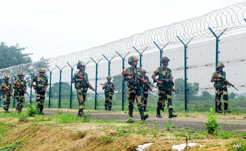
To keep illegal activities at bay, India has built a fence for a length of about 3,180 kilometers. You know, there are still some stretches that have not been fenced due to the presence of rivers, forests, and marshy land.
Indian States Bordering Bangladesh
1. West Bengal (Longest stretch)
West Bengal shares the longest border with Bangladesh, which is approximately 2,217 kilometers. And no doubt, between the two nations, it is also the most trafficked area for both trade and travel. Major border points are Petrapole – Benapole, Hili, and Mahadipur. Besides, there is a strong cultural connection here, reflected in the shared language, food, and festivals. But the thing is, the issue of sharing Teesta waters is a matter that has not been settled yet.
2. Assam
Assam shares a border with Bangladesh for about 262 kilometers. And talking about the main border areas in the state, those would be the Mankachar-Rowmari and Karimganj-Sheola. No doubt, from India’s side, the region is very significant both for security and the transport sector. Even so, it suffers from floods and illegal migration, which remain the problems.
3. Meghalaya
And then comes Meghalaya, which also shares a 443 km border with Bangladesh. The Dawki-Tamabil is the most popular crossing point, especially because of the beauty of the Umngot River. There are also border haats which boost local trade and cooperation, and it has been like this for a while now.
4. Tripura
Tripura borders Bangladesh on three sides over a stretch of about 856 km. The Agartala-Akhaura crossing is among the busiest ones. Sabroom-Ramgarh is another important link, which is connected with the Maitri Setu bridge.
5. Mizoram
Just like that, Mizoram shares about 318 kilometers of the border. The Kawrpuichiah Integrated Check Post is the main crossing. The infrastructure is getting better here with the support of India’s Act East Policy.